
Grand Circle
The Grand Circle is America’s largest concentration of national parks, monuments, recreation areas, state parks, native American archaeological sites, tribal parks, scenic byways, and more. It encompasses a sizeable portion of Utah, Colorado, Arizona, New Mexico, and a slice of Nevada. Our tours don’t cover the entire region but they do include many of the top attractions. Here’s a list of the highlights.
Nevada: Las Vegas, Mesquite, Valley of Fire, Hoover Dam, Lake Mead Utah: St. George, Zion, Mexican Hat, Goosenecks State Park, Moki Dugway, Moab, Arches National Park, Canyonlands National Park, Dead Horse State Park, Goblin Valley State Park, Capitol Reef National Park, Highway 12, Grand Staircase Escalante National Monument, Bryce Canyon, Kodachrome Basin State Park, Red Canyon, Cedar Breaks National Monument Arizona: Grand Canyon, Marble Canyon, Antelope Canyon, Horseshoe Bend, Lake Powell, Monument Valley, Grand Canyon Caverns, Meteor Crater, Walnut Canyon, Sedona, Jerome, Petrified Forest National park New Mexico: Four Corners, Santa Fe, Acoma, Albuquerque, Petroglyph National Monument, Aztec Ruins Colorado: Mesa Verde National Park, Durango, Silverton, Ouray, Glenwood Springs
And More!
This is America’s highest concentration of scenic beauty and adventure! National Parks, National Monuments, State Parks, National Recreation Areas, Tribal Parks, Scenic Routes, Historic Sites, and so much more!
Come join us as we explore America’s Grand Circle!
Grand Circle Tour Description
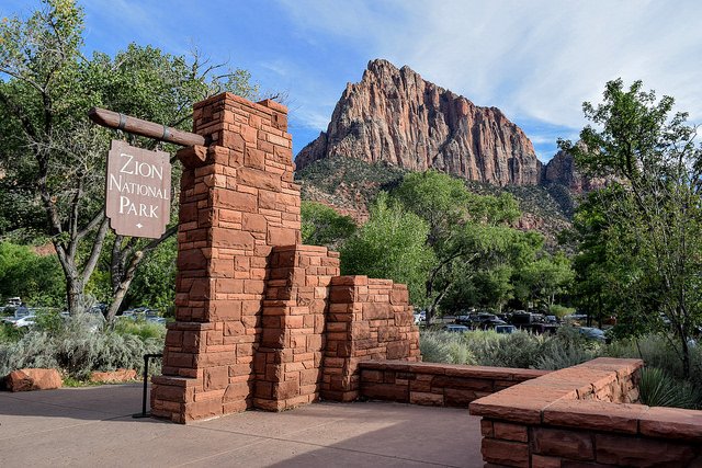
Our most popular tour since 1998, the tour provides an excellent opportunity to experience up close and personal seven National Parks (Zion, Bryce, Capital Reef, Arches, Canyonlands, Mesa Verde, and the Grand Canyon), plus Monument Valley and Antelope Canyon. The tour involves driving through 1,900 miles of beautiful mountains, deserts, and mountain valleys, and includes two of America’s most scenic highways.
This nine-night, nine-day tour includes 9 breakfasts, 2 lunches, and 2 dinners. The tour is loaded with activities that complement the beautiful national parks we visit. Key activities include Four-hour Narrow-Gauge Railroad ride from Durango to Silverton, Colorado; Navajo-led Monument Valley back-country tour; Navajo-led Antelope Canyon tour; and a float trip down a 10-mile section of the Colorado River. Our tour includes many more activities than most tours visiting Southern Utah.
Our groups are small with eight to ten passengers. When there are more than 10 guests, we take a second guide and vehicle. We use comfortable modified raised roof vans designed to fit 15 passengers, plus luggage. Unlike other companies, we do not fill the vans to capacity as we want you to have a comfortable, uncrowded traveling experience.
We begin the tour is St. George and end in Las Vegas and visit the states of Utah, Nevada, Arizona, New Mexico, and Colorado. We pass through three Native American reservations as well. Our guides are the best in the area. They usually are natives of Southern Utah and have a lifetime of stories and insights to draw upon. There is no substitute for experience. They provide a comprehensive overview of the history, geology, plant life, and culture of the West.
![]()
10-Day Grand Circle Tour Route
| Title | Category | Address | Description | |
|---|---|---|---|---|
 | Point Imperial | 36.27905049512824, -111.97907283160285 | Linked to the Cape Royal road, Point Imperial is the highest viewpoint (8,803 ft) on the north rim with panoramic views of the Vermilion Cliffs, House Rock Valley, Marble Canyon, Navajo Mountain, and nearby Mount Hayden. | |
| Cape Royal / Angels Window | 36.119974200568315, -111.94993549680325 | Located 20 miles from the hwy 67 junction and 23 miles from the Grand Canyon Lodge. Highlights: Angels Window, Wotan's Throne, best panoramic view of the canyon. You can see the Desert View Watchtower from here. | |
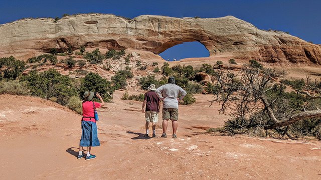
| Mesa Arch | Mesa Arch | Located in the Island in the Sky district of Canyonlands. An iconic landmark, Mesa Arch is perched on the canyon rim at the end of a 1/2 trail. Views of canyonlands and La Sal Mountains. | |
| Bears Ears | Bears Ears, Utah, USA | The Bears Ears are a pair of buttes located in southeastern Utah on Cedar Mesa within the Bears Ears National Monument. A good places to see them is from Natural Bridges National Monument on Hwy 95. | |
| Wilson Arch | Wilson Arch | Located 25 miles south of Moab on SR 191. It's an easy scramble up a dirt trail and rocks to access the bottom of the arch. There are pull-outs on both sides of the highway. | |
| Newspaper Rock | Newspaper Rock | A 200-square ft sandstone petroglyph panel covered with more than 650 symbols evidencing nearly 2,000 years of human history. Located off State Road 211 approx. 12 miles west of Highway 191. There are no fees to visit. | |
| Navajo National Monument | Navajo National Monument | Established in 1909 to preserve the archaeological and cultural heritage of the Ancestral Pueblo people who built Tsegi Phase villages within the natural sandstone alcoves of the canyons. Betatakin, Keet Seel, and Inscription House were occupied from approximately 1250 AD to 1300 AD and are among the best preserved cliff dwellings in the state of Arizona. | |
| The Wave | The Wave Trail, Kanab, UT, USA | Located in the Coyote Buttes North area of the Vermilion Cliffs National Monument. A six mile round trip hike in required to get to The Wave. A permit is required to see The Wave. Only 20 permits per day (10 on-line and 10 walk-in) are available. | |
| Forrest Gump Point | US-163 Scenic Mexican Hat, UT 84531 | Turn out on U.S. Highway 163 north of Monument Valley. Best known for its role in the Movie Forest Gump. If you've seen the movie, you will recognize the landscape. | |
| Valley of Fire State Park | Valley of Fire, Nevada, USA | Nevada's first state park known for its miles of bright red Aztec sandstone outcrops nestled in gray and tan limestone, Valley of Fire State Park contains ancient, petrified trees and petroglyphs dating back more than 2,000 years. | |
| Gold Butte National Monument | Gold Butte National Monument, NV | Gold Butte National Monument covers nearly 300,000 acres of remote and rugged desert landscape in southeastern Nevada near Lake Mead, where dramatically chiseled red sandstone, twisting canyons, and tree-clad mountains punctuate desolate stretches of the Mojave Desert. The brightly hued sandstone provides a stunning canvas for the area's famously beautiful rock art. | |
| Virgin River Gorge | Veterans Memorial Hwy Littlefield, AZ 86432 | Located between St. George, UT and Beaver Dam, AZ is a long canyon that has been carved out by the Virgin River in northwest tip of Arizona. The Virgin River rises on the Colorado Plateau and created the topography of both Zion National Park and the Virgin River Gorge. The Gorge connects the southwestern rim of the Colorado Plateau and the northeastern part of the Mojave Desert. | |
| Snow Canyon State Park | Snow Canyon State Park, Ivins, UT | Snow Canyon State Park is a state park of Utah, featuring a canyon carved from the red and white Navajo sandstone in the Red Mountains. The park is located near Ivins, Utah and St. George in Washington County. Other geological features of the state park include extinct cinder cones, lava tubes, lava flows, and sand dunes. | |
| Kolob Canyons | Kolob Canyons, UT | The Kolob Canyons section of Zion National Park is located at Exit 40 on Interstate 15, 40 miles north of Zion Canyon and 17 miles south of Cedar City. A five-mile scenic drive along the Kolob Canyons Road allows visitors to view the crimson canyons and gain access to various trails and scenic viewpoints. | |
| Kanarraville Falls | Kanarraville Falls, Kanarraville UT | Kanarra Creek Canyon Trail is a 4.3 mile heavily trafficked out and back trail located near Kanarraville, Utah that features a waterfall and is rated as moderate. The trail is primarily used for hiking, walking, nature trips, and bird watching and is accessible year-round. | |
| Cedar City | Cedar City, UT, USA | Cedar City’s central location makes an ideal base camp for visiting Zion National Park, Bryce Canyon, the North Rim of the Grand Canyon, Cedar Breaks National Monument, and many other attractions on the Markagunt Plateau. It’s also close to the increasingly popular Kanarra Falls, Navajo Lake, Cascade Falls, and Kolob Canyons where some of our favorite hikes are located including the Timber Creek and Taylor Creek trails. | |
| Cedar Breaks National Monument | 4730 UT-148 Brian Head, UT 84719 | Situated about two miles south of the town of Brian Head, Cedar Breaks is often described as a higher and more eroded-down version of Bryce Canyon with its crimson and coral pink pinnacles, hoodoos, and buttresses. | |
| Panguitch Lake | Panguitch Lake, Utah, USA | The word “Panguitch” comes from Southern Paiute Indians and means “Big Fish”. Panguitch Lake sits in the Dixie National Forest and is adjacent to Scenic Highway 143 between the towns of Panguitch and Brian Head, Utah. | |
| Panguitch | Panguitch, UT, USA | Located in the valley between the Markagunt and Pausaugunt Plateaus, Panguitch, Utah is home to some of the most majestic scenery on earth. A Native American Paiute word meaning “Big Fish,” Panguitch is undoubtedly named for the famously plentiful lakes in the nearby mountains, hosting some of the largest rainbow trout in the state and ideal for year-round fishing. | |
| Red Canyon | UT-12 Panguitch, UT 84759 | Red Canyon is a scenic roadside attraction on Byway 12 in Utah’s Dixie National Forest. This section of the forest has views of hoodoos formations. These are similar to what you’ll view in nearby Bryce Canyon National Park. | |
| Bryce Canyon National Park | UT-63 Bryce, UT 84764 | ||
| Kodachrome Basin State Park | Kodachrome State Park Rd Henrieville, UT 84736 | ||
| Escalante Petrified Forest | 710 Reservoir Rd Escalante, UT 84726 | ||
| Escalante | 755 W Main St Escalante, UT 84726 | ||
| Head of the Rocks Overlook | Head of the Rocks Overlook | ||
| Kiva Koffeehouse | 7386 Hwy 12 Mile Marker Escalante, UT 84726 | ||
| Lower Calf Creek Falls | Boulder, UT 84716 | ||
| The Hogback | UT-12 Boulder, UT 84716 | ||
| Burr Trail | 37.90113472958641, -111.42481284601672 | ||
| Anasazi State Park Museum | 460 UT-12 Boulder, UT 84716 | ||
| Boulder Mountain | 38.01169138257505, -111.35876076648856 | ||
| Torrey | Torrey, UT, USA | ||
| Capitol Reef National Park | Fruita, UT, USA | ||
| Goblin Valley State Park | Goblin Valley, Utah, USA | ||
| John Wesley Powell River History Museum | 1765 Main St Green River, UT 84525 | ||
| Canyonlands National Park | Island in the Sky Road, Moab, UT, USA | ||
| Dead Horse Point State Park | Dead Horse Point, Utah, USA | ||
| Arches National Park | Arches National Park Entrance Station, Arches Entrance Road, Moab, UT, USA | ||
| Moab | Moab, UT, USA | ||
| Hole N" The Rock | 11037 US-191 Moab, UT 84532 | ||
| Ouray | Ouray, CO, USA | ||
| Silverton | Silverton, CO, USA | ||
| Durango | Durango, CO, USA | ||
| Mesa Verde National Park | Mesa Verde National Park | ||
| Cortez | Cortez, CO, USA | ||
| Four Corners Monument | Four Corners Monument | ||
| Twin Rocks | Twin Rocks, Utah, USA | ||
| Bluff Fort | Bluff, UT, USA | ||
| Sand Island Petroglyph Panel | Bluff, UT 84512 | ||
| Valley of Gods | Valley of the Gods Road, Mexican Hat, UT, USA | ||
| Moki Dugway | Moki Dugway, Utah, USA | ||
| Goosenecks State Park | Goosenecks, Utah, USA | ||
| Mexican Hat Rock | Mexican Hat Rock, Mexican Hat, UT, USA | ||
| Forrest Gump Point | US-163 Scenic Mexican Hat, UT 84531 | ||
| Monument Valley | Monument Valley, AZ, USA | ||
| Antelope Canyon | Upper Antelope Canyon, Arizona, USA | ||
| Lake Powell | Wahweap, AZ, USA | ||
| Glen Canyon Dam | Glen Canyon Dam Bridge, Page, AZ, USA | ||
| Horseshoe Bend | Horseshoe Bend, Arizona, USA | ||
| Navajo Bridge | Navajo Bridge, Marble Canyon, AZ, USA | ||
| Lee's Ferry | Lees Ferry Road, Marble Canyon, AZ, USA | ||
| Cliff Dwellers Stone House | House Rock Valley, Arizona, USA | ||
| Grand Canyon | North Rim, AZ, USA | ||
| Jacob Lake Inn | Jacob Lake, AZ, USA | ||
| Kanab UT | Kanab, UT, USA | ||
| Coral Pink Sand Dunes State Park | Coral Pink Sand Dunes Road, Kanab, UT, USA | ||
| Zion National Park | Springdale, UT, USA | ||
| St. George | St. George, UT, USA | ||
| Las Vegas | Las Vegas, NV, USA |


